42: Kennerley Grave Lane
An ancient highway explored
Davenport Station home | Index to History pages
Note: This article has more loose-ends and speculations than usual; it's been hard to find information. Any comments will be very welcome.
The Road
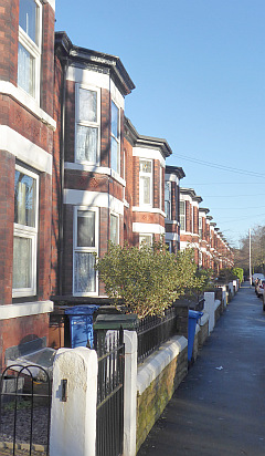
Kennerley Road, Davenport, which connects Buxton Road with Bramhall Lane, is a very old highway, dating back many centuries; here we will explore some of its ancient history, as well as the buildings which line it today.
Until 1900 Kennerley Road was part of the boundary between the townships of Bramhall and Stockport, and the two sides have different characters.
The South side
The southern side of the road was historically part of Mile End farm, a tenanted farm on the estate of the Davenports of Bramall Hall, and remained so until the last of the Davenports sold most of their holdings and left the area in the late nineteenth century. Among the earliest to be sold, in 1877, was the land between Kennerley Road and the Stockport - Whaley Bridge railway (opened in 1857) which became a private estate, 'Davenport Park', Perhaps inspired by Victoria Park, begun in 1837, in 2022 it remains private land. Parking of cars by commuters is very strongly discouraged.
The park's history will form another article; The houses facing the half of Kennerley Road nearest to the station are on the land purchased for the Park, but not always considered part of the Park. The houses there were built by local builders, including William Winbolt, to a general plan seen elsewhere in Davenport.
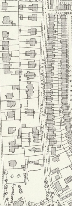
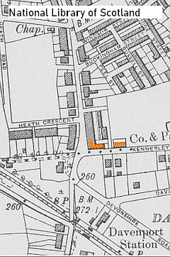
The map below, rotated to follow the road (Bramhall Lane at the top) records the road in 1935.
Some plots nearest to the Buxton Road end had already been sold before the Park was planned. All the original buildings in this area have since been replaced by new buildings. The 1851 census lists four households, and two unoccupied.
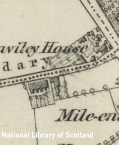
Map extract from 1872 showing all the buildings then on the road, and the extended grounds of Heaviley House.
One of the lost houses, 'Cronton Lodge', in the centre of the extract above, is of interest to us as it appears in one of our other articles, on Samuel Jackson. The Jackson family were coopers - barrel makers - and took over the cooperage business at 12 Higher Hillgate from the Rigby family, who hailed from the village of Cronton in Lancashire. James Rigby was born there in 1803; by 1841 he had moved, with his wife Catherine and his sons Henry and John, to Stockport and established his coopering business.
By 1861 he had retired to a new house, built for him, which the couple named 'Cronton Lodge', for their birthplace. By 1871 he had died; Catherine initially kept the house, but later it had a series of residents until demolished and replaced by two blocks of flats in the plain rectangular style of the 1960s and 70s.
Near the other end of the road, No.53, stood a house which has a connection with another of our features. It was, for some time the home of Robert Brotherton Whitfield, an electrical engineer who, with, David McClure, founded the Mersey Dynamo Works.
The house was demolished in the late 1960s, replaced by Cobal Court.
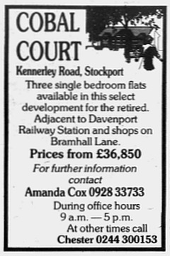
Advert from 1969.
At the Buxton Road end of the road, the Kennerley Road side was occupied by part of the extensive grounds of Lyndhurst, a large villa (now renamed 'Fedora House' and converted to apartments with additional buildings on the former grounds), which fronts into Davenport Park.
The North side
The northern (Stockport) side of the Road may once have been Davenport land, but by the 1840s it had passed to the Bamford Hesketh family, who were related to the Davenports by marriage.
The 1850 tithe map shows the two fields that adjoin the road were being farmed for grass by a John Bardsley, apart from a plot at the junction with Buxton Road; this plot is covered in detail in the adjacent column.
The remainder of the field adjacent to Kennerley Road was leased in 1896 to William Winbolt, a prolific local builder. His life and times are recorded in another feature with aslo covers the suffrage work of his brother's wife Hannah Winbolt.
The first houses to be built on the road by Winbolt were at the Bramhall Lane end, as marked in colour in the 1897 map extract below.
The house 'wrapped round the corner' is numbered 235 and shared the building with a smaller house, no.233; and the other is 104 Kennerley Road.
Both are large three-storey villas, and as such became candidates for conversion to business use. No.235 became a Burgon's grocery, and was later divided to form three shops, the two new ones becoming 106 and 108 Kennerley Road. By 1914 no.104 had become a dentist's surgery.
The story of this group will form a later feature. From alongside no.104 runs a side street, Abergele Street, which leads into an estate of smaller houses which has a feature of its own,
Winbolt Row
Beyond the junction with Abergele Street is
a long row of semi-detached houses - numbers 20 to 102 (even) .
These eouses, built by the form of William Winbolt houses are of medium size, originally aimed at small business owners and skilled workers, although some did employ live-in servants in the early days. Very similar rows by the same builder can be found nearby on Garner's Lane and Oakfield Road.
As built, most had three bedrooms and, as normal at the time, two cellar rooms below. At first sight they are all the same pattern but 96-102 are on a rectangular plan rather that the 'T-shape' of the rest, and 56-62 have an extra storey at the rear, resulting in a different roof arrangement.
All would have been provided with Winbolt's stone gateposts with 'quatrefoil' tops and a place where a house name could be carved. Unlike some other streets, most of the posts survive, as there is not enough space in the small front garden.to remove them to keep a car, even with the posts removed.
Only a handful of the posts bear names; they were originally built for rent rather than sale, and by this date house numbers were in use by the Post Office, so names were not necessary.
Early tenants
To give an idea of the occupants in early days, Here is a list of the names, ages and occupations householders of the Winbolt houses in 1901 soon after their completion. * signifies Stockport-born.
20 George Boothby (26) Cheese Factor ? Seed Merchant *
22 Arthur G Dean (40) Electrical and Telegraph engineer
24 Alexander Hardie (28) Agent for carpet manufacturer *
26 Edward Smith (33) Assistant superintendant Post Office *
28 John ?Heydown (34) Brewer's clerk
30 Alfred Broadhurst (35) Building Contractor Manager *
32 Richard N Scott (38) Linen agent
34 Alfred L Samuel (44) Railway bookstall clerk
36 Alice Price (65) Living on Own Means
38 William B Johnson (36) Grocer. Shopkeeper
40 William Heal (51) Cycle factor
42 Fred D Liend (41) Fancy Box Manufacturer *
44 Elizabeth Firth (58) Retired hotel keeper
46 William Henry Howard (43) Bank Cashier
48 William Brentnall (53) retired baker
50 Fred Broadhurst (27) Carpenter and Joiner *
52 Sarah J Holme (63) Living on Own Means
54 [empty]
56 David J Briggs (33) Boot shoe shopkeeper
58 [empty]
60 John James Corlett (51) Traveller Wholesale drapery
62 Jeremiah Simpson (54) Cashier
64 Albert Hennings (31) Secretary to metal smelting company *
66 Allan Nicolson (37) Stock and shares broker
68 George Henry Owen (37) Cloth Finisher
70 [Empty]
72 Arthur Henry Nesbitt (33) Ironmonger. Shopkeeper
74 Francis M Moseley (26) Commercial traveller (velvets)
76 Alice Ann Ogden (61) wife
78 Edward R Manning (38) cotton manufacturer salesman
80 John Huxley (33) Railway Account Collector
82 Charles W Kent (41) Warehouseman Drapery
84 Nancy Whiteside (60)
86 William Moore (35) Mercantile Clerk
88 Joseph Shotton (60) Retired publican
90 William J Pullen (33) Solicitors Clerk
92 Sarah Ann McLachlan (54) Widow
92 [boarder] Walter S H Morris (28) Clergyman Church of England
94 Mary Ann Dearson (70)
96 Herbert M Bowden (34) Railway Clerk
98 Ruth Greaves (60) Servant, in charge
100 William Sutton (32) Felt Hat manufacturer *
102 Edward Hope Dodd (29) Pianoforte tuner, music instructor.
I haven't researched any of these houses in detail; if you live there and would like to know your house history in detail, please let me know.
Thanks and Sources
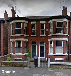
Thanks as always to fellow local historian Sue Bailey for pointing me in the right direction, and also to the current owner of no.14a for the information and photograph.
On-line sources:
Ancestry.co.uk,
Findmypast.co.uk
British Newspaper Archive
Cheshire Tithe maps
National Library of Scotland maps
Heginbotham, Henry. Stockport Ancient and Modern, Vol.2. Second Edition. London: Sampson Low, Marston and Co., 1892.
A. Benedict Davenport. History and Genealogy of the Davenport family in England and America from A.D. 1086 to 1850. New York: S.W.Benedict, 1851.
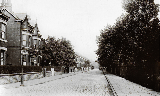
Kennerley Road, circa 1905. Grenville series postcard.
Kennerley Grave Lane
Today's Kennerley Road has had several names. Some sources say it once was Davenport Lane, but for many years it was recorded as Kennerley Grave Lane. A name change to (briefly) Kennerley Grove Lane, and then Kennerley Road around 1900, References in old documents vary the name of the interred person - Kenric, Kennally, Kenworthy, Kennerly - but all sources agree that there was a grave somewhere along the lane. I explore this question further in 'Who Was Kennerley' below.
Beating the Bounds
The oldest mention of the road I have found relates to accounts of 'beating the bounds', when once a year the Stockport Town Clerk and others would walk the boundary of the township. A record of such a perambulation in 1612 records that they 'passed through the lane to Kenric's grave up by lorens Davenport dore to loose Crosse'. Various scholars, including Benjamin Varley, in his book The History of Stockport Grammar School interpret this to refer to the house of a Lawrence Davenport, which was on the north side of the road at the junction with Buxton Road. The 'dore' interpreted as 'door' suggesting that the house was there in 1612. Old maps show a homestead at that location, the only one on the road for many years. The 'loose Crosse' refers to Lowe's Cross which at that time stood at the junction of Mile End Lane with the main road.
Later 'beatings' also mention Kennerley. A 1738 record reads:
... along after the Ring fence abt. the Late Hobson's now Mr Cales Estate to Brock Lane and so down that Lane by the end of Squire's Lane down to Kennerly Grave & so up the High Road to Stockport Moor...'Mr Cales Estate' suggests Cale Green Farm, but Brock Lane (Garner's Lane maybe) and Squire's Lane (possibly Bramhall Lane) are difficult to map on current roads. There is no mention of Lawrence Davenport or his house.
An 1854 repetition of the event was recorded by Joshua Brown, Superintendent of Stockport police:
... we struck into the fields and took a zigzag course along the hedges to Adswood Lane, across the lane through a garden and again through fields until we reached Kenworthy Lane ... this lane took us to the turnpike on Buxton Road at Mile End ...The above is quoted from a booklet written by a descendant of Joshua Brown. A map dated 1837, reproduced in the booklet, suggests that 'Henworthy Lane' continues across Bramhall Lane and along the original course of Garner's Lane (before it was altered by the railway company) as far as the boundary with Cheadle. (The 'Henworthy' on the map is surely a transcription error by the engraver of the map. )
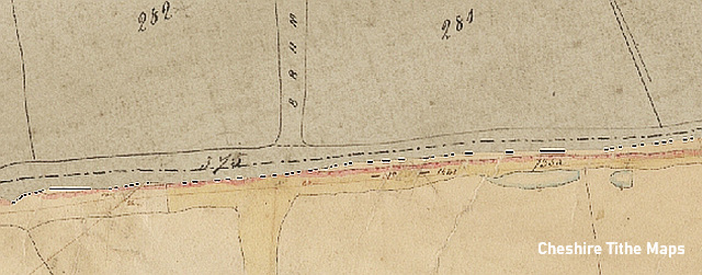
Further evidence of this is that the Tithe Map dated 1850, while not naming Kennerley Road, shows it as the principal route; Bramhall Lane had what is known in modern times as a 'staggered crossing' at that point.
Who was Kennerley?
A short answer to the above question is - 'Nobody knows.'
Historian Henry Heginbotham writing in the 1880s tells us:
However, he admits that 'there is no account of the Kennerley who was buried therein' and states that 'Heaviley House is built upon its site'. I haven't been able to find a map which captions the grave, as distinct from the house which existed at that point, although a building of some sort is marked on all the maps I have consulted, except a map dated 1800 on which no building appears.There were Kennerleys as early as the fourteenth century, witnesses of deeds in connection with the Davenport family of Bramall, but the situation of the grave is clearly marked on old maps of the district ... at the junction of Kennerley Grave Lane with the London Road.
You might also ask, why was he (or she) buried at this lonely spot and not in a churchyard? It is well documented that - until the practice was banned by law in 1823 - someone taking their own life was denied burial in a Churchyard and buried at a crossroads in order to 'confuse the spirit of the restless victim. ' Some of these 'crossroads graves' are still marked on maps today. Could it be that the Kennerley grave was actually at the Bramhall lane crossroads?
James E. Macdonald, writing in the local newspaper in 1929, ignores the above theory, instead claiming that the 'grave' was simply an alternate spelling of 'grove' or 'greave' meaning a small wood. He also places Lawrence's house as the farmhouse on the opposite side of Kennerley Road, but this doesn't explain the separate plot on the Heaviley House side.
The house on the corner
As mentioned above, Benjamin Varley, in his history of Stockport Grammar School, mentions a house on the corner of Kennerley Grave Lane ('now called Kennerley Road to eliminate the lugubrious touch') as the home of Lawrence Davenport, presumed to be a member of the Davenport family.
Sadly he gives no date and doesn't enter into Lawrence's genealogy, and at the time of writing haven't definitely found it either, but it is likely that it refers to a gentleman of that name who was buried in 1641 at St Mary's Church in Stockport. A book published in New York in 1851 by A. Benedict Davenport 'of the twenty-fourth generation' does mention a Lawrence Davenport. According to this, Lawrence's father, John, married Margaret, a daughter of William Davenport (the third) of Bramhall who died in 1575. However, this doesn't agree with other available records.
Lawrence is mentioned in the will of Humphrey Hall, Yeoman, of Heaviley dated 1637 and written in the free spelling of the era:
St Mary's Church register for 1596 lists the baptism of 'John sonne of Lawrence Davenport of Bramhall' . There's no birth record for Lawrence himself, as he was born before Stockport's records began. He died in 1641 and was buried at St Mary's Church in Stockport. What happened to his son John is obscure.And to my Lovinge neighbour and deere Frend Lawrence Davenport 2 s [shillings]. And to Everie one to whom I am godfather 12 d [pence]. And out of all the rest and residue of my goodes my will and mynde is that my debtes and funerall Expenses shal be paide and discharged And after the payment and discharge of my debtes funerall expenses and legacies before menctioned I do give and bequeathe all the then rest and residue of my goodes Cattells and Chattells of what name nature or condicion soever Unto my said two daughters Anne and Katheryne to be Equallie devyded betweene them.
The nearby Mile End Hall is also known to have been a Davenport family residence around this time. The original of that building was later replaced in the 1800s; that house was demolished in 1962.Nothing appears to be known about Lawrence's house, but Henry Heginbotham states that it stood on the site by the junction with the Stockport - Buxton Road. I haven't found any details about this original building: a map of 1800 shows no building there. Most likely it was a wooden-framed 'black and white' house, but we have no evidence.
Heaviley House
After this long gap in our chronology, during which the house at the corner was the only house on Kennerley Road, and at an unknown date was demolished or fell down. We resume our chronology with a Conveyance [lease] ... dated 29 November 1837 made between (1) Lloyd Hesketh Bamford Hesketh and (2) Thomas Butterworth.
Although assigned a different plot number, the site was by that time owned, like the rest of the two fields to the north, owned by the Bamford Hesketh family. There's not much available about Mr Butterworth, but he was probably the Thomas Butterworth that was living in Greek Street, listed among the 'Gentry' in an 1834 directory.
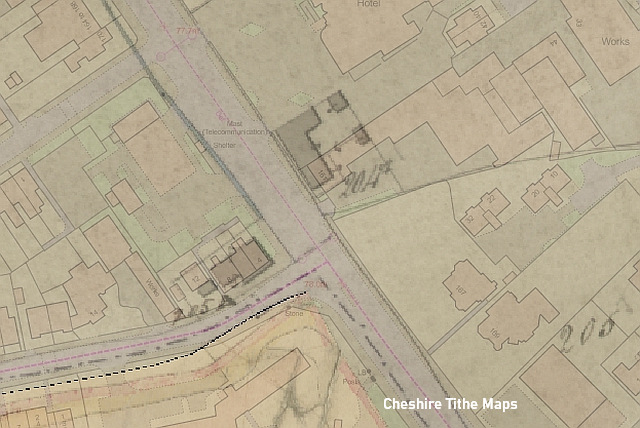
The land in question comprised most of the corner site of our medieval exploration. The image above shows the area as it was on the 1850 Tithe Map, overlaid on a modern map. The present 4,6 and 8 Kennerley Road fit almost neatly over the site of the 1850s building, and indeed it is the same building. The boundary between Stockport and Bramhall, as it was until 1901, is shown.
The implication is that a new house on the site, to be called 'Heaviley House', was commissioned by Butterworth; at that time Greek Street was becoming built-up, while Heaviley was still a hamlet amid fields. He's hard to find in any later directories, which strongly suggests that he moved away, or died.
A second entry in the Land Registry, for 19 December 1850, shows that the lease of Heaviley House was taken on by James Ollerenshaw, of whom we know some more details. He may have been renting the house previously, as he is listed, aged 25, with his wife Lydia Ollerenshaw, in the 1841 census of Heaviley, although the 'Heaviley House' name is not given. His occupation is given as cotton waste dealer, which was something of a speciality in Stockport at the time. James's mother, Lucy Ollerenshaw, also lived in Heaviley House and has her own directory entry.
The 1851 census finds James, aged 36, born in Stockport, his wife Lydia, 33, born in Derbyshire, two servants (male and female). Lucy had her own servant. By 1861, they had moved on to greater things: their home by then was Bramhall House, the villa in Mirrlees Fields, Hazel Grove which which was demolished (by then in a derelict state) in 2014. James supplemented his cotton waste business with farming, working the 82 acres with the help of two live-in farmhands.
The 1861 census for Heaviley House lists 30-year-old James Duncroft, an Oldham-born 'stocks and shares broker' as the householder, with his wife Maria Duncroft, baby sons Isiah Duncroft and James Duncroft cared for by live-in nurse, and a housemaid, The outbuildings also appear on the scene: recorded in the 'Lodge to Heaviley House' is Thomas Fletcher, coachman and gardner, with his wife and family. The Duncrofts, who had previously lived at Norris Bank House in Didsbury Road, did not stay long, pehaps because their infant daughter died in 1862.
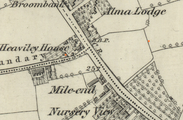
A subsequent owner had procured extra land to create gardens, as seen on this 1882 map. The coach-house and stables are marked in colour above.
In 1863 Heaviley House was let, and for the first time we get a description of the house:
The next recorded tenant was Charles Howard Stanley, a 'master bobbin turner' with a works and timber yard in Portwood. He was born in Stockport in 1813 and baptised at Stockport Presbyterian New Chapel. He died in 1871; his widow Selina Stanley stayed on for a while until the house was sold. The 1871 census includes the Coachman, James Gosling, his wife and two children, as well as Selina's father George Sharp and a domestic servant, Sarah Boden.TO BE LET, with immediate possession: that well and substantially-built HOUSE, known as HEAVILEY HOUSE, pleasantly situated near the London Road, at Heaviley, and about 10 minutes' walk from the Stockport railway station. It contains three excellent entertaining rooms, butler's pantry, five bed rooms, bath and closet rooms, wth spacious kitchen, laundry, and good cellaring. There is a three-stall stable, coach house, and out-offices; also two greenhouses, which shew for a heavy crop of grapes. If preferred, the property may be sold. Particulars may be known on application to Mr LOONIE, agent, 5, Warren-st., Stockport.
The house went to auction again in August 1871; the notice for this, together the firm's properties in Portwood has also survived; the chief difference from 1863 is the mention of a cottage in addition to the coach-house, stables, greenhouse and gardens. Davenport station gets a 'mention, as three minutes' walk; from the house.
The residents in 1881 were John Cooper Barrow, an iron merchant (ironmonger) , born in Stockport in 1834, and baptised at the High Street Presbyterian Chapel, with his wife Judith Elizabeth Howard Barrow (née Leah) who he married in 1875. (The name Howard suggests a connection with the previous occupant Charles Howard Stanley.) He retained ownership of their former home, a shop at 38 Little Underbank in Stockport town centre. The lodge was the home of Thomas Littler, the family coachman with his wife and two daughters.
By 1891 John had retired, and they had three sons: John Cooper Barrow (jr)(14), Frank Barrow (9) and Arthur Lindsay Barrow (7), all students at a Theological College. By then they has a whole team of servants: governess, cook, housemaid, and in the adjacent 'lodge' a gardener, James Weston, his wife Maria Weston, listed as launderess, and their 11-year-old stepson John Moore. The following year, 1892, tragedy struck the household when John Cooper Barrow died.
The next mention I have found is a lease dated 25 March 1886 to Thomas Meadows, a builder and contractor born in Hindley, Lancashire. It's likely that he had held the freehold for some time. The 1881 census lists him with his family at Shaw Heath House, no 111 Shaw Heath. By 1891 they had moved to Hollywood House, an eighteenth-century manor house built for mill-owner Joseph Dale that stood in what became Hollywood Park in Edgeley. His was the last family to live in Hollywood House, which was demolished in 1897.
The 1901 census found Thomas Meadows (aged 62) living in Heaviley House with his wife Mary (aged 43) and large family; so large that the census enumerator speeded up his visit by writing only the initials of the nine children. By 1911, with his roster of live-in children. Heaviley House clearly became too small for them and they moved to Alma Lodge, a large villa on the Buxton Road - shown on the 1882 map - which survives much enlarged in 2022 as a hotel. At the time, it was common for wealthy men to move from one big house to another.
Thomas Meadows was more than just a humble house builder: he was a partner with his brother William in the firm T & W Meadows, which also traded as brickmakers and timber merchants. Based in premises in George's Road, Heaton Norris, and employing over 200 men, they were capable of large projects like the building of Palmer Mill in Stockport. It is believed that they owned the short-lived Davenport Terra Cotta, Brick & Tile Company works on Garner's Lane, a site which later became a golf course and finally the Bracadale Road housing estate.
The next residents, listed in 1911, possibly the last in the building's history as a single house, were John Eaton with his wife Maria Eaton and six children. John was the owner of J. Heaton & Co, fur cloth manufacturers of Warp Mill, Salford and Darley Dale. He was in the habit of experimenting with chemicals that might improve the company's product, and in July 1917 in the Darley Dale works in Derbyshire he made one experiment too many. Not wearing a mask, he inhailed a gas which made him ill; he managed to get home to Stockport, where he died two weeks later. The family remained in Heaviley House for a while: they appear in the 1921 census - Marie and her ten children aged from 20 to 37. The adress given was 176 Buxton Road, implying that the main entrance was on the end of the building. By 1934 they had removed to 216 Wellington Road North, Heaton Chapel. Eldest son Harold and other family members carried on the business, both at Salford and Darley Dale, producing furs for the hatting industry.
12-18 Kennerley Road
This map, dated 1917, shows that although the Eaton family were still in residence, a portion of the grounds had been sold for house building; the land had been purchased (actually a 999 year lease) in 1909 by a builder, Josiah Briggs (born in 1855 in Lancashire) who, by 1911, built a large arts-and-crafts house, no.14, for himself and his family.
Alongside, he built a semi-detached pair of houses, nos. 16 and 18; no.16 was retained for Josiah's brother William Briggs, a foreman in the firm, and his family. No.18 is notable for being, by 1911, the home of William Sutton, son of Thomas Sutton, partner in the Stockport hat-manufacturing firm Sutton and Torkington. William, who worked in the firm, lived at 100 Kennerley Road when it was new, later moving to the newly-built larger house no.18 with his son Harry and a servant.
Josiah Briggs' firm was responsible for several large projects in Stockport, including Pugin-designed St Mary's Catholic Church in Heaton Norris, and the Centenary Hall of Stockport Sunday School. Biggest of all was Stockport Town Hall, Briggs taking on the contract after the builder who offered the lowest estimate pulled out, and Briggs' £56,881 was the second lowest. Unfortunately, he lived to regret this: by the time it opened by the then Prince and Princess of Wales on 7 July 1908, he had lost about £3000 on the deal. In 1912 Josiah Briggs was declared bankrupt: the business and the house, alomg with the were sold at auction. He died in 1917.
The head of the next household at no.14 was James Emery, a retired cotton thread manufacturer; business was William Emery & co., Howard Street, Stockport. They moved to no. 14 from 495 Buxton Road, Stepping Hill. James never married; the 1921 census shows him living with his sisters Sarah Emery, Hannah Florence Emery and Elizabeth Emery-Wright, and a servant, Isabella Hadfield. By 1939, there was only Sarah, and long-serving maid Isabella. Sarah died in 1942, aged 80.
The detached house No.12 was a late-comer on the Kennerley Road scene, dating from 1932, around the same time that Kennerley Garages Ltd bought land at the rear for their business, which in 2023 trades as an Esso service station. The first owner was Maurice Benjamin Bennett, 'Inspector of drilled machine parts' who lived there with his family until 1945.
The Stables and Gardener's House
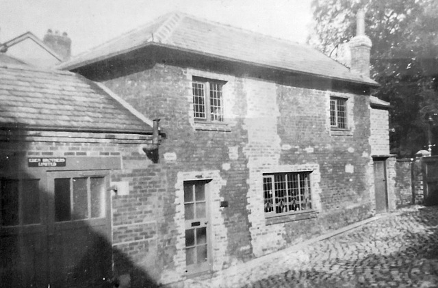
The range of outbuildings, including the gardener's house, was later purchased by the owners of no.14. The photograph above, dated around 1900, appears to show the changes made to the building to create an entry on the opposite side. The name over the doors on the left reads 'Eden Brothers Limited.' I haven't been able to confirm details of this firm, although the 1901 census lists an an Arthur George Dean, Electrical and Telegraph Engineer, living at no. 22 Kennerley Road, a short distance from the building. There may also be a connection with George William Eden, an engineer who in 1911 lived at 'Orion', 26 Frewland Avenue in Davenport, and had 10 children. Two of his sons were engineers, and one of the daughters was listed as 'shorthand typist' motor car engineers.
From then until 2022, the buildings continued in commercial use as 14a Kennerley Road: Latterly 'Fireplaces and Furniture' in 2008 were replaced by 'Jigsaw UK' and 'Bargains4U'. The name 'Kennerley House Stables' has been attached to the building in recent years, but it really should have been 'Heaviley House Stables.'
The shops
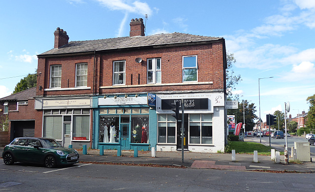
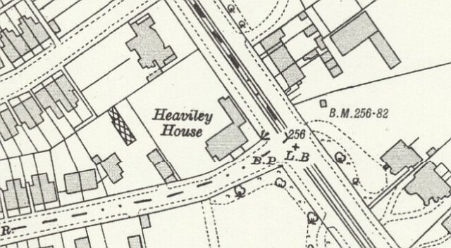
A couple of mysteries surround the later life of Heaviley House itself (pictured above in 2022). The 1911 census lists the the house as being on Buxton Road, round the corner from Kennerley, and maps from that time and onwards show a building attached at one corner to Heaviley House and facing on to Buxton Road. One map shows it divided in to three small houses. It's not there now: what was it and when was it removed? Secondly, the part of the main house which forms no.8 has clearly been much rebuilt at some time, in addition to receiving a shop front and a garage to the side. It has detail differences in the window opening (apart from modern window changes), and a gable end, contrasting with the hipped roof at the other end. What happened there? A curiosity is that the division between no.4 and no.6 is in the centre of a window.
A 1934 directory suggests that the house was used as a British Legion club, and the 1939 National Register shows the building as 4, 6 and 8 Kennerley Road. At no.4 were John Aspinall, a structural engineer, with his wife Norah Aspinall; at no.6 Freda Seddon, shop manager, and Sarah Crawshaw, 'domestic duties', no.8 was vacant. It appears that the conversion to three shops with flats above had been done by that date. The shops have had many uses over the years: unfortunately there is no easy way - unless a reader knows one - to research shops of this period. A picture from 1993 shows all three merged into 'The Kennerley Discount Linens Centre' - boarded up and abandoned. Since 2008 we have seen website experts, 'The Smile Clinic', 'Pretty Petals' florist, a slimming shop, Eaglegate estate agency, and no doubt many more then and in the future, although the building is not 'listed.' Alan James Hurst, Architect, has been a fixture at no.8 for some years.
The boundary marker
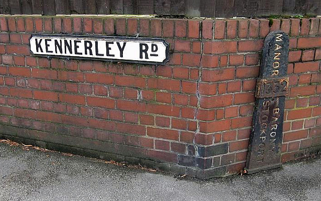
On the corner of Kennerley Road and Buxton Road is a cast-iron marker carrying the words MANOR AND BARONY STOCKPORT and the date 1332. This is one of several such markers which survive around Stockport, marking points on the boundary of the township as it was around 1800. The street name sign is in the later style used from the 1890s; evidence of the road's change of name, and the transfer of this side of this side of the road from Bramhall (who used a different style) to Stockport.
'Barony' is a name for a group of land-owning Manors, which in this case included the Manors of Stockport, Poynton and others. Bramhall and Cheadle were not included in the Barony. Edward Warren became Baron of Stockport in 1332, but the markers probably were installed sometime in the 1800s. Other examples can be found at the junction of Buxton Road and Higher Hillgate (I haven't yet found this); the front wall of the George & Dragon inn in Hazel Grove; built into Portwood Bridge, King Street East; a factory in Shield Street; and the junction of Offerton Lane with Marple Road. Some of them have been moved from their original location. Markers of a different design, but the same purpose, remain at the junction of Cherry Tree Lane and Buxton Road in Great Moor, and at 73 Garners Lane, Davenport. Both carried the Stockport shield and lettering which has rusted away. A stone marker in Adswood Lane West, Cale Green, marks the boundary between Stockport and Cheadle Bulkeley.
Written by Charlie Hulme April 2023. Comments welcome at charlie@davenportstation.org.uk