Who was Winifred? Some Street names explained
Written by Charlie Hulme
Davenport Station home | Index to History pages
Early days
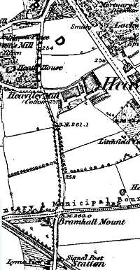
Above: the Bramhall Lane area, circa 1875. Between the Blossoms Inn and the station the traveller along the lane would pass between fields, interrupted only by views of brewer Henry Bell's mansion Heath House (later renamed Heathfield), Ephraim Hallam's 1859-built cotton mill, and cotton waste dealer Samuel Rigby's home, Bramall Mount. All three of these buildings still exist, with different uses, in 2009.
Winifred Road residents
Over the years
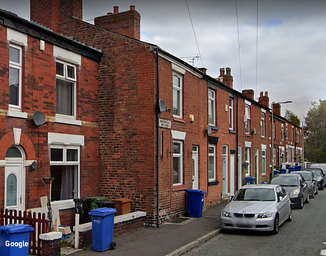
Winifred Road has changed little over the years, except that both sides are now lined with parked cars. A significant change has been the demise of the shops originally provided.
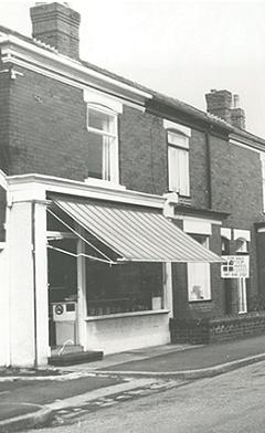
The butcher's shop (above) at No.62 was the last shop to survive, in business until 1994, before being converted to a house. The small building alongside no.62 was perhaps part of its role as a butcher's. Could animals have been slaughtered there? By 1902 the butcher was Thomas Lowe; in 1911 he was a widower living there with his daughter Sarah Lowe (39) and his nephew John Alfred Drummond (30) - both 'assisting in the business.' By 1934, John Alfred had taken on the business; by 1965 the butcher was M.Marsh.
There were two small grocery shops in Winfred Road: Signs of conversion from their former use are evident today. The one at No.64 was run by William Bostock until at least 1934. The shop was still in business in 1965 but seems to have been converted to a house soon afterwards. Stockport-born William Bostock was recorded there in 1911, aged 45, with his wife Frances, three-year-old daughter Phyllis, and niece Sarah Thornhill Harter (16) who was working as a felt hat trimmer.
No. 89, converted in 1975, has a rendered frontage with modern bay window, and is also conspicuous by its white frontage, a feature which can be seen on many of the 'corner shops' included in rows of houses of the period - no doubt to advertise their existence.
At the east end of the street, No.8 was at various times a confectioner, a greengrocer's shop, and maybe some other business; it was converted to a house in 1988.
The houses of Winifred Road were intended for rent to skilled workers, junior clerks, and those of similar incomes. Most of them in 1901 had small families, although one or two houses must have been quite crowded. No. 40, for example, was the home of Alfred G. Bassett, a plumber, his wife and their six sons aged between 8 and 22.
At No.22 Winifred Road in 1901 was Alfred James John Sampson, confectioner (born in Cambridgeshire), his wife Mary and their seven children aged between 3 and 16 - the two eldest working as assistants to their father. By 1911, only four children remained at home, and Alfred was no longer an employer, but a worker - confectionery foreman. Perhaps he went to work at the Squirrel Confectionery works which had taken over the former cotton mill nearby, now the industrial estate known as Heaviley Mill.
At 80 Winifred Road in 1911 were George and Frances Evans, newly married, George was an electric tram guard, employed by the Borough Council. Their neighbour at 82, William Hughes, was an electric tram driver. In 1905 the council had bought the tramway line from Stockport to Hazel Grove, which ran along Buxton Road, passing the end of Winifred Road, and converted it from horse to electric power.
An area at the Bramhall Lane end of Winifred Road was used for some time as a Builders' Yard by William Winbolt & Sons, to be eventually replaced by the Electricity Sub-station which still operates in 2022.
Clubs
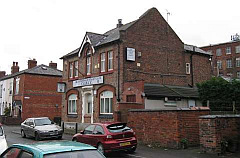
The Cale Green & Heaviley Conservative Club in Dundonald Street (above) - which latterly advertised itself as 'The Dundonald Street Club C.G.H.C.C.' - was built in the 1880s to the a design by James Hunt of Stockport.
The club closed in 2013, and in 2014 the building with its surrounding land was offered for sale. The club building became apartments, with a new house alongside.
Also in the street was the Reform Club, based in former houses at nos. 13-19 and, latterly known as the Cale Green Social Club. This was converted back to houses in the 1990s.
'Bomb in Attic'
Working in the attic of a house in Winifred Road, Stockport, electrician Harold Adams found an unexploded incendiary bomb. Mr Adams, who was in the Home Guard, took it to Stockport Civil Defence Headquarters, where it was handed over to the Police.
(Manchester Evening News - Friday 13 May 1955)
Contributions are very welcome at at info@davenportstation.org.uk
Revised to
include more streets in Heaviley, 2022
Street names can have a fascination, but the people who
named many of Davenport's streets in the period around
1900 seem to have been concerned with making the place
sound leafy and rural, with Heath Crescent, Beech Road,
Beechfield Road, Oakfield Road, Ashfield Road, Elmfield
.... by contrast, though, the builders of the streets of
small houses north of Kennerley Road seem to have
had other things on their minds. Winifred Road, Countess
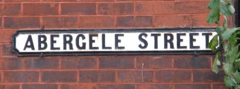
Street, and joining them, Abergele Street, for example.
What's behind these names?
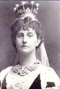
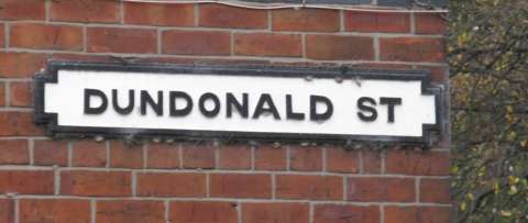
Dundonald Street, a little nearer Stockport, is also part of the pattern, because all these street names relate to Winifred, Countess of Dundonald, who lived at Gwrych Castle, near Abergele in North Wales.
Winifred Bamford-Hesketh was the only child of Robert Bamford-Hesketh, Lord of the Manor of Cheadle Moseley and owner of much land in our district as well as the Welsh estate.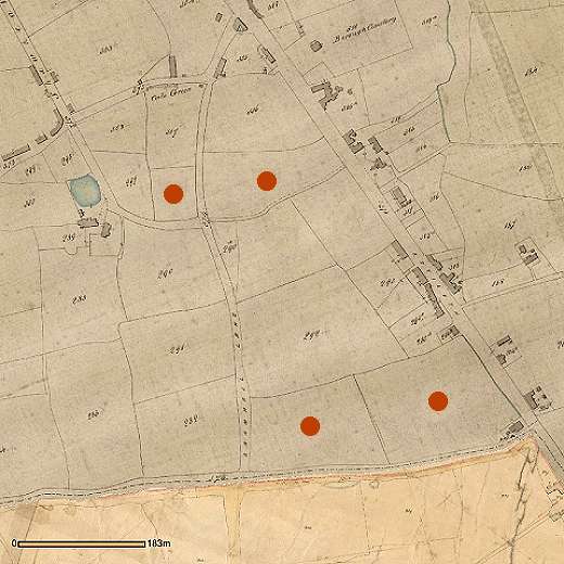
The tithe map above (made around 1850) shows the triangle of roads formed by the Stockport - Buxton main road, Bramhall Lane, and Kennerley Grove Lane, now Kennerley Road. At the time this area was part of the Cale Green ward of Stockport; the boundary with Bramhall township followed Kennerley Grave (or Grove) Lane.
Ownership of the land in this neighbourhood at that time was something of patchwork, with different owners owning fields of pairs of fields which they or their ancestors bought as investments as they became available, probably sold by the Davenports of Bramhall Hall to raise money. The four marked by red dots on the tithe map above were among those owned in 1850 by Lloyd Hesketh Bamford-Hesketh, and when he died passed with the estate, including Gwrych Castle (and much land in Abergele) to his son Robert Bamford-Hesketh. The estate also included the eponymous Bamford Arms inn.
The owners of the adjacent land developed it for building from the 1850s onwards: Ephraim Hallam built his cotton spinning mill around 1860, and houses for his managers on the Bramhall Lane frontage. Some of the adjacent land was used for a small park and a row of almshouses - on Hallam Street - which he presented to the town of Stockport. For what happened to the Hallam land, see our article Ephraim Hallam's legacy.
On 18 September 1878 Winifred, aged 19, married Douglas Mackinnon Baillie Cochrane (1852-1935) - in what is said to have been an 'arranged marriage.' Robert Bamford-Hesketh presided over many developments in the Abergele area, until his death in December 1881, when the estate, including the Cheshire holdings, passed to his only child Winifred, who, with her husband, began to develop their land in the Stockport area, where there was a great demand for housing. On the death of his father in 1885, Douglas Cochrane became the 12th Earl of Dundonald, and Winifred Countess of Dundonald.
First to be developed were the two fields towards the north of the triangle. A new street, named Dundonald Street, was laid out, connecting Bramhall Lane with the Buxton Road, with short offshoots named Lilac Street and Violet Street - colours perhaps connected with the Dundonald or Bamford Hesketh family in some way - and Chatswood Avenue. The origin of the latter name is not clear, although in Sydney, Australia there is an area of that name and a street named Dundonald Road.
The terrace on the south side of the street carries a plaque 'Jubilee Cottages 1887' which dates them nicely to Queen Victoria's jubilee year. Compare the area in the map below with the shape of the field on the tithe map, and you can see how the shapes of the back gardens follows the original curves.
To the north of the Dundonald Street land, St George's Church was built, from 1892-97, followed by the vicarage and schools. This land had been bought by Wakefield Christie (who had already left the area by then) of the hatting family and donated for the creation of the Church.
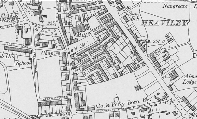
The map above is dated 1899 and shows the Dundonald Street area completed, the houses along Bramhall Lane in place, and a short street (called Winifred Street at the time) leading to an area which is clearly just in process of construction. To the north, streets of small houses had appeared, built by someone who believed in street names with aristocratic connotations, such as Buckingham Street and Windsor Street. Some of the houses were so small and lacking in facilities that they have since been replaced in slum clearance programmes.
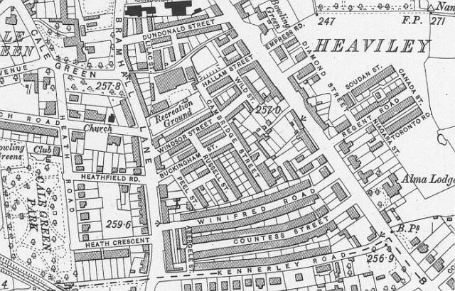
In 1896 the the other two Dundonald fields were leased to William Henry Wild, a builder who lived close by at 77 Beech Road; the space was repidly filled with houses, and by 1907, date of the map above, the familiar scene of today was largely complete. Following the scheme of family names, perhaps attached as a condition of the lease, the Countess and her home town were commemorated in the two long roads called Winifred Road and Countess Road, and the short cross street called Abergele Street. William Henry Wild died in 1899, and the firm was taken over by William Winbolt, who I believe built most of the houses.
Nos. 10-16 Countess Street, a terrace, appears from their name plaque 'Sydney Mount' and old-style brickwork, stands out from the rest. The land was leased in 1896 to Charlie Carroll Siddall, a master joiner; he was born in 1857 North Carolina, USA, during a stay there with his parents. He lived at no. 10 Countess Street, and worked at the Hawfield Cabinet Works in Hawfield Street, Stockport. His father, Peter Goddard Siddall, was manager of a weaving mill.
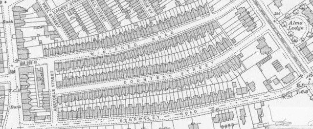
A more detailed map of the 'Winifred' streets, dated 1934. At the eastern end, facing the main road, opposite the villa 'Alma lodge' larger houses with spacious gardens were provided.
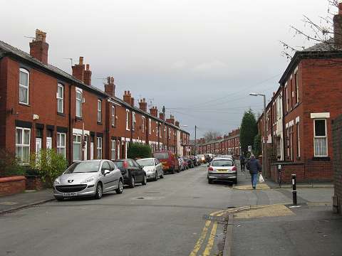
Above: Winifred Road in 2009, with Abergele Street joining on the right.
By the time these three streets appeared on the scene, Stockport had changed to a different style of name sign, still cast iron but with larger lettering than those found in older parts of the town.
More Dundonald street names
The Dundonald estate included land in nearby Heaviley, on the other side of the Stockport - Buxton Road, which was also developed for housing. The street names there reflect the life and times of Winifred's husband Lieutenant General Douglas Mackinnon Baillie Hamilton Cochrane, 12th Earl of Dundonald, KCB, KCVO. He was commissioned into the Life Guards in 1870, served in the war against the Mahdi in Sudan, including the relief of Khartoum in 1885 and the second Boer War in 1899. His time in Africa is remembered by the naming of Soudan Road (older spelling of Sudan), and his loyalty to the Crown by Colonial Road, Regent Road, Diamond Road (perhaps a reference to Queen Victoria's Diamond Jubilee in 1897) and Empress Road - Queen Victoria was Empress of India - which later became part of Nangreave Road. Elsewhere in Stockport there are Boer War street ames: Ladysmith Street and Kimberley Street, which may also be the work of the Dundonalds.
Regent Road absorbed Birchenall Lane which led to an existing group of houses: 'Birchenall Buildings'. An 1880s-style Stockport council cast-iron nameplate still adorns the buildings, now 57-63 (odd) Regent Road, whilst the Dundonalds' streets have a later version of plate. The Birchenall family had occupied houses in the area for many years, latterly working as brickmakers. The Land Registry records a 'Conveyance dated 17 August 1836 made between Lloyd Hesketh Bamford Hesketh, John Birchanell [sic] the elder and John Birchanell the younger.' Their buildings include what may have been their workshop behind; did they form bricks by hand and take them to the brickworks on nearby Lowndes Lane for baking, or did they have their own kiln? Today the back yard is occupied by eight garages.
In 1902 Cochrane was named as General Officer Commanding the Militia of Canada; he lived there with his family for two years. Hence we have Canada Street, Niagara Street, and Toronto Road. The Dundonalds owned large tracts of land in other nearby townships: Dundonald Roads can be found in Cheadle Hulme and off School Lane in Didsbury, in the latter case accompanied by a Countess Road and a Winifred Road.
Gwrych Castle
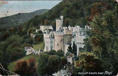
Winifred, Countess of Dundonald, died in 1924, leaving the castle in her will not to her husband but to King George V, and the then Prince of Wales (who later became King Edward VIII). However, the gift was refused and the castle passed to the Venerable Order of Saint John. In 1928, the widower Earl of Dundonald re-purchased the castle for £78,000, selling the contents to meet the cost. He died in 1935 and the castle passed to his son, the 13th Earl. During World War II, the was requisitioned by the Government and housed 200 Jewish refugees, and in 1946 it was sold, passing over the years to a series of private owners. It was open to the public, with attractions such as bars and restaurants, from 1948 until 1985. In 1989 it was bought by an American businessman, who allowed it to fall into a derelict state, in which it stands in 2012, despite attempts at rescue, and a restoration campaign led by Mark Baker, who was a teenager when the campaign began in the 1990s.
By 2015, Another owner with a plan for a hotel had come and gone, and the castle was then owned by property consultancy EPM UK, who again had aspirations for a 'luxury 77 bedroom hotel with spa and banqueting facilities' and even gained planning permission. Predictably this also failed, although with support from the owners, work was carried out by Gwrych Castle Preservation Trust volunteers to create a visitor centre at the Castle as a first part of its restoration.
In 2018, the planning permission ran out and the castle was offered for sale by auction. Through the intervention of the National Heritage Memorial Fund and the Richard Broyd Charitable Trust, the castle was purchased by Gwrych Castle Preservation Trust, on behalf of the nation, and hold regular events around the estate, and raise funds for the restoration of the castle.
During the 'lockdown' period in the 2020s, the Castle became an icon of popular culture when chosen as the stage for the TV programme 'I'm a Celebrity, Get Me Out of Here' which was prevented from using its previous site in Australia.
Sources and References
This feature has been made possible by several on-line sources, notably, Ancestry.co.uk, Findmypast.co.uk, Cheshire Tithe Maps online, Cheshire Directories, and The Land Registry. There is a selection of street directories on our own website.
Stockport Heritage library has a collection of photographs and press cuttings, as well as microfilms of local newspapers and electoral registers.
Special thanks to Joe Graham for Heaviley information.
Written by Charlie Hulme, 2009. Last updated July 2022.