A postcard from Davenport, No.1
From time to time postcards of Davenport become available on eBay and
elsewhere, opening a window into the past: here is a selection which we
hope is of interest, with special thanks to Peter Wadsworth for access
to his collection.
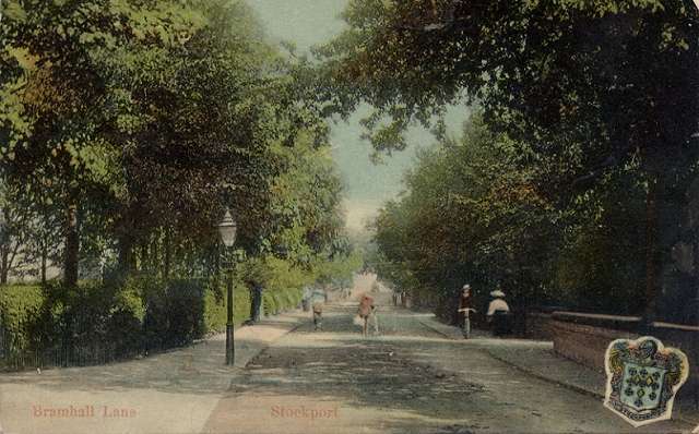
This view looking towards the station from the Bramhall direction is
no.1930 in the 'Milton Glazette series' published by Woolstone Bros. of
London but printed, like most colour cards of the time, in Germany. It
was posted in August 1907 and gives a good idea of Edwardian Davenport;
the original photograph, which might have been taken somewhat earlier,
would have been in black and white: the colours have been added by hand
in preparation for the printing process, distant details like St
George's spire being lost. Bramhall Lane is a narrow country
lane, and cycling on the pavement is nothing new - whilst someone else
seems to be walking their bike down the middle of the road!
To the left is the entrance to the drive of Highfield, the large
house once owned by Stephen Christy of the Stockport hatting
family.
The
drive to the right belonged to Beaconsfield, another of the large
mansions from Davenport 's Victorian origins - home in 1910 of
Isaac
Leigh, 'gentleman' - demolished in the 1960s and replaced by the Mormon
church. Three other large houses stood lay on the right hand side
behind the trees. The first two were
the homes of two hat manufacturers, William Ward and William
Lees.
Beyond, on the right-hand side, is the entrance to The Crescent. In the
distance, the road rises over the railway station bridge. In the
corne of the card is Stockport's coat of arms. These Milton Series
cards can be found for very many places in Britain.
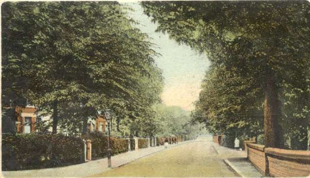
This one dates from about the same period, but the viewpoint is on the
other side of the Lane, bringing into view the houses on the west side.
The two pairs of semi-detached houses nearest the camera were quite new
at the time, but Oakfield Terrace beyond is somewhat older.
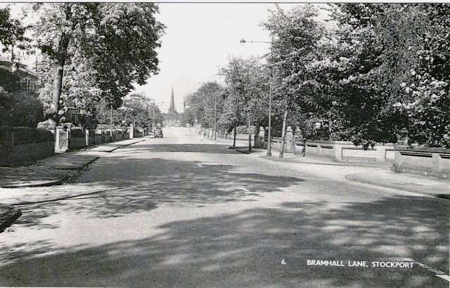
Forward to circa 1950 and a
real photograph from the end of the era of this type of local view
postcard. The photographer has, by accident or design, stood in almost
exactly the same place as his Edwardian predecessor. Bramhall
Lane has
been widened on the right-hand side, taking away part of the grounds of
'Beaconsfield' and replacing the front wall with a standardised brick
style which can also be seen elsewhere on Bramhall Lane. The drive to
Highfield is now more clearly defined: the house was by then occupied
by the Mayson family who had purchased it after World War I and
apparently removed part of it to create a more manageable home. The
church spire forms the focus of the scene.
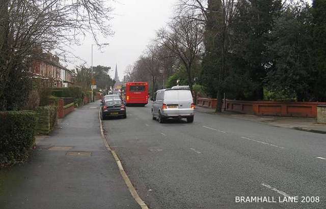
Our
own picture taken in 2008: achieving the exact same viewpoint as the
other two could have fatal consequences, so we have resorted to the
pavement. Some of the brick walls on the right remain, but the three
large houses behind them have been replaced by more modern
accommodation. The nineteenth-century houses in Oakfield Terrace to the
left are now more visible, thanks to the removal of a tree. Highfield
was pulled down in the 1980s, and replaced by the present apartments of
the same name; the drive, now with stone posts either side, now
forms
the entrance to the nursing home which occupies what were originally
houses built some time in the 1920s on land released by the Mayson
family. And yet, despite all these changes, the view is not
really so
different from 1907; it would be even more similar had we taken the
picture on a summer day.
Updated May 2015. Comments welcome at info@davenportstation.org.uk
|
|
